Piramidi & Atlantide in Antartide - Pyramids & Atlantis in Antarctica
Index
Italiano
Ipotesi Barbiero: Atlantide si trova sotto i ghiacci del
Polo
English
1)
Location hypotheses of Atlantis
2)
Hypothesis Barbiero: Atlantis could be buried under the ice 'Antarctica
3)
Scientist claim to possibly have found Pyramid like structures in Antarctica
4)
Atlantis Under Antarctica?
5) In
‘The Myth of the Twelve World Pyramids’ author James Donahue explained the
legend in 2006
6) Le varie "Atlantidi" e Piramidi sul mio blog - Various "Atlantis" and Pyramids on my blog
Ipotesi Barbiero:
Atlantide si trova sotto i ghiacci del Polo
http://www.ilnavigatorecurioso.it/
Quella di Atlantide è la civiltà perduta per eccellenza,
la “madre” di tutte le civiltà secondo alcuni, ed è considerata fin dai tempi
antichi uno dei più impenetrabili misteri dell’archeologia. La sua ricerca vede
impegnate da molti secoli generazioni di studiosi nel vano tentativo di dare
una risposta credibile al problema della sua ubicazione. Nonostante le tante
ipotesi avanzate sul misterioso continente perduto di Atlantide, finora non è
ancora stato trovato nulla che possa confermarne la passata esistenza.
Non potrebbe essere allora, si sono chiesti alcuni, che
Atlantide non sia finita sotto il mare, e che non possiamo vederla perché è
nascosta da qualcos’altro? La pensa così chi ritiene che in realtà l’Antartide
fosse un tempo priva di ghiacci e proprio qui si trovasse l’antica civiltà
perduta. Tutto iniziò a metà degli anni ’50 con l’osservazione di uno studioso
di mappe antiche, il capitano statunitense Arlington H. Mallery, che
esaminandone una scoperta alcuni anni prima in Turchia ebbe un’illuminazione. La
carta, realizzata nel 1513 dall’ammiraglio turco Piri Ibn Haci Mehmet, meglio
noto come Piri Re’is (“l’ammiraglio Piri”), fu disegnata su una pelle di
gazzella colorata ad acquarello e perduta per oltre 400 anni. Nel 1929, durante
la trasformazione del vecchio Palazzo Imperiale di Istanbul nel museo
archeologico Topkapi, la mappa ricomparve e destò sorpresa perché collocava
l’America Meridionale nella corretta posizione longitudinale in rapporto
all’Africa: un fatto insolito per le mappe del ’500. Ciò che colpì Mallery,
però, fu qualcos’altro. Egli si convinse che il lembo di terra raffigurato
all’estremo sud della mappa rappresentasse la costa dell’Antartide libera dal
ghiaccio. Ma a far diventare esplosiva questa ipotesi furono le successive
osservazioni dello studioso Charles H. Hapgood, secondo il quale la precisione
della longitudine sulla mappa di Piri Re’is non si poteva spiegare sulla base
della scienza cinquecentesca. In particolare esisteva, a suo dire, «una
concordanza sorprendente con il profilo della Terra della Regina Maud
nell’Antartide» rilevato solo nel 1954 attraverso sondaggi sismici. Ne
conseguiva che la mappa si doveva basare su carte più antiche realizzate da
viaggiatori di una civiltà sconosciuta, ma progredita, esistita prima dell’Era
glaciale. Chi ipotizzò che questa civiltà sconosciuta fosse Atlantide non
furono scrittori come i coniugi Rand e Rose Flem-Ath o Graham Hancock, che
negli anni ’90 dedicarono a quest’idea libri molto venduti, bensì un ingegnere
italiano, Flavio Barbiero, che per primo ne parlò nel 1974 nel libro Una
civiltà sotto ghiaccio.
L’ipotesi di Flavio
Barbiero
flavio-barbiero-una-civiltà-sotto-ghiaccioLa teoria di
Barbiero prende avvio dall’ipotesi che circa 12 mila anni fa la Terra fosse
inclinata diversamente da com’è oggi. Ruotava perpendicolare sul piano
dell’eclittica per cui le stagioni coincidevano stabilmente con le fasce climatiche.
Alaska e Siberia, così come l’Antartide, erano prive di ghiacci, a differenza
di Europa e America nord-occidentale ricoperte dai ghiacci eterni.
In Antartide, in particolare, fioriva una civiltà
marinara molto evoluta, dove era stata inventata l’agricoltura, la metallurgia
e dove fiorivano architettura, tecnologia, arte e scienza di alto livello
mentre nel resto del mondo l’uomo era all’Età della pietra. Circa 13 mila anni
fa, dopo 2 mila anni di progressi, questa civiltà chiamata Atlantide subì una
devastante catastrofe che la annientò quasi interamente. Una cometa o un
asteroide, del diametro di una decina di chilometri, colpì la Terra nei pressi
della Florida provocando una serie di trasformazioni globali istantanee. L’asse
di rotazione della Terra cambiò, i poli cioè si spostarono di colpo di migliaia
di chilometri, assumendo la posizione attuale. L’impatto sollevò una nube di
polveri tale da innescare piogge torrenziali, con il conseguente abbassamento
delle temperature e l’avvio della Grande glaciazione. Il raffreddamento fu così
veloce da cogliere di sorpresa i grandi mammut che pascolavano per la Siberia,
come dimostrerebbe il fatto che nello stomaco di un esemplare ritrovato c’erano
ancora i resti dell’ultimo pasto di erbe tipiche delle zone temperate: si era
congelato senza avere avuto il tempo di decomporsi. Ma l’effetto più devastante
fu l’onda ciclopica provocata dall’impatto del bolide: un’onda che avrebbe
travolto tutte le terre, compresa Atlantide-Antartide. Solo grazie alle sue
flotte di imponenti navi, parte della popolazione riuscì a mettersi in salvo e
a raggiungere l’America, l’Africa e l’Asia. Sull’isola madre, intanto, prese a
nevicare per settimane e forse mesi, finché una coltre gelata, spessa decine di
metri, seppellì definitivamente Atlantide. I superstiti, sparpagliati per il
mondo, iniziarono a interagire con gli uomini paleolitici, insegnando loro a
coltivare i campi e dando una forte accelerazione allo sviluppo della civiltà,
originando l’Età neolitica.
Indizi a sostegno
della teoria
La teoria è molto suggestiva, ma ci si chiede: quali sono
le prove? Innanzitutto, risponde Barbiero, la scomparsa improvvisa di decine di
specie animali che 13 mila anni fa popolavano l’emisfero settentrionale:
mastodonti, mammut, rinoceronti lanosi, renne, bisonti antichi, cavalli,
cammelli, tigri dai denti a sciabola e così via. In secondo luogo, le
importanti somiglianze tra i racconti dei popoli di tutto il mondo, dalla
Bibbia alla Mesopotamia, dal mito dell’isola di Mu nel Nord America a quello di
Lemuria) dove c’è sempre un diluvio che travolge il mondo e poi qualcuno che
viene dal mare e insegna a coltivare la terra. Tali leggende sarebbero la prova
che il ricordo dei fenomeni seguiti al cambiamento di asse della Terra è
rimasto profondamente radicato nella memoria dei popoli.Altre leggende diffuse
potrebbero svelare che il corpo celeste che colpì la Terra fu probabilmente una
cometa. Basta pensare a quell’antica superstizione secondo cui le comete
sarebbero messaggere o portatrici di gravi calamità. E Atlantide deve
corrispondere all’Antartide perché, dice Barbiero, «in nessun altro posto sono
stati trovati resti archeologici. Una civiltà del genere, in Europa per
esempio, li avrebbe lasciati per forza». Inoltre è l’unica che rispecchi la
descrizione che ne dà Platone: un’isola avente una superficie di milioni di km
quadrati, circondata da un oceano a sua volta circondato da una fascia continua
di continenti, ricca di metalli e favorita (prima del diluvio) da un clima
mite. A ulteriore riprova di ciò Barbiero sostiene che «tutti i planisferi
anteriori alla scoperta dell’America, sono in realtà carte dell’Antartide:
tutti i popoli antichi concepivano il mondo come una grande isola pressoché
circolare, circondata dall’oceano, e questo a sua volta da terre
irraggiungibili e misteriose». Osservando per esempio il planisfero tratto
dalle Grandes Chroniques de Saint-Denis (1364-1372) Barbiero vi riconosce «il
mare di Ross in alto a destra, la baia di Mackenzie a sinistra e il mare di
Weddell in basso» oltre alla «fitta rete di canali analoga a quella descritta
da Platone». Per non parlare della carta di Piri Re’is che riprodurrebbe il
profilo dell’Antartide scoperta dai ghiacci. Secondo Barbiero, tutte queste
mappe medievali sarebbero riproduzioni di carte geografiche più antiche,
provenienti magari dalla biblioteca di Alessandria prima che fosse distrutta. Barbiero
riconosce che questi possono essere considerati solo indizi, e che solo il
ritrovamento di tracce archeologiche di Atlantide potrebbe trasformarli in
prove. «Basterebbe trovare anche un solo mattone per dimostrarne l’esistenza e
rivoluzionare tutta la storia antica e la geologia». Tuttavia, il “mattone” di
Atlantide ancora manca. Non solo non sono state mai trovate tracce di vita
preistorica sull’Antartide, ma non ce ne sono nemmeno nei luoghi in cui gli
atlantidei avrebbero riparato dopo il diluvio. Se davvero questi uomini così
evoluti portarono la civiltà in America, Africa e Asia 10 mila anni fa, non ne esistono
tracce. Secondo l’archeologia classica, i primi segnali di civiltà superiore
sono molto più recenti e risalgono a circa 4 mila anni prima di Cristo, con
qualche rara eccezione.
La risposta di Barbiero è che gli atlantidei, essendo
marinai, si stabilirono principalmente sulle coste dei vari Paesi: coste che,
in seguito allo scioglimento dei ghiacci, finirono sommerse a 130 metri di
profondità. Allo stesso modo, i resti delle città atlantidee create quando il
Sahara era fertile sarebbero finiti sotto la sabbia del deserto.
La diffusione
dell’agricoltura
Prima dell’avvento della datazione al radiocarbonio 14,
ogni questione relativa all’origine ed alle caratteristiche di una qualsiasi
cultura antica veniva risolta sulla base dello scenario diffusionista, che
nella sua formulazione più essenziale era il seguente: l’agricoltura si è
sviluppata per la prima volta nel Medio Oriente, in quella fascia di terra
denominata Mezzaluna Fertile. Qui sono sorte le prime culture neolitiche e,
successivamente, tra il quinto ed il quarto millennio a.C., le prime civiltà
superiori, che si sono diffuse poi in tutto il resto del mondo. Campo obbligato
di ricerca era allora lo studio comparato delle civiltà, delle loro mitologie,
tradizioni, usi e costumi, conoscenze scientifiche e tecnologiche, che forniva
ampio supporto alla teoria diffusionista, mostrando una sostanziale identità da
un capo all’altro del pianeta. Dopo l’introduzione delle datazioni al
radiocarbonio 14, la teoria diffusionista è crollata. Si è scoperto, infatti,
che l’agricoltura è nata contemporaneamente in almeno sei aree del mondo senza
alcuna relazione apparente fra loro: il Centro e Sud America, la Mezzaluna
Fertile, l’Africa Centrale, la Cina orientale ed il Sud Est asiatico. Sono saltate
anche la maggior parte delle relazioni temporali fra civiltà diverse, stabilite
in base ai presupposti della teoria diffusionista. Nel Mediterraneo, ad
esempio, le civiltà megalitiche di Malta e dell’Europa nord-occidentale si sono
rivelate più antiche dei loro presunti modelli mesopotamici ed egizi. Per
reazione al diffusionismo si è venuto consolidando nel mondo scientifico uno
scenario diametralmente opposto, secondo cui le culture antiche sarebbero nate
e si sarebbero sviluppate contemporaneamente in più parti del mondo, senza
contatti e influenze reciproche. Nel nuovo contesto, quindi, l’esame comparato
delle civiltà è divenuto anatema! Nell’uno e nell’altro scenario si inseriscono
sottoscenari, che tentano di superare le difficoltà dei primi con ipotesi più o
meno ortodosse. Per esempio nello scenario pre-carbonio 14 ha avuto credito
l’ipotesi di Atlantide quale ponte di diffusione della civiltà dall’Eurasia
all’America.
Nello scenario post-carbonio 14, invece, Atlantide non
trova più un suo spazio definito, e tuttavia emergono tutta una serie di
elementi che proverebbero l’esistenza di una civiltà molto avanzata in epoca
preistorica. Naturalmente questi elementi sono negati e “combattuti” dalla
scienza ufficiale, perché destabilizzano il quadro generale, senza offrire in
cambio scenari alternativi accettabili.
Cataclismi
geologici ricorrenti
In effetti nessun archeologo, o storico antico, è mai
stato capace di immaginare uno scenario in grado di risolvere le innumerevoli
contraddizioni e semplificazioni cui gli scenari ufficiali danno luogo. Va detto
che questa incapacità non è colpa degli storici e degli archeologi, ma
piuttosto di branche scientifiche quali la geologia e la climatologia, che a
tutt’oggi non sono in grado di dare una risposta soddisfacente ad uno dei
problemi fondamentali della storia geologica della Terra e delle specie viventi
che vi si sono sviluppate.
Questa storia è caratterizzata da lunghissimi periodi di
stabilità, inframmezzati da crisi brevissime e violente, durante le quali si
hanno da un lato eruzioni vulcaniche imponenti, orogenesi, cambi climatici,
inversioni del campo magnetico, variazioni del livello marino ecc. Dall’altro
estinzioni di massa, emergenza di nuove specie, cambio radicale degli equilibri
ecologici. Nella storia della Terra si contano cinque grandi estinzioni
animali, a livello planetario, ed innumerevoli altre minori, o anche totali ma
a livello più o meno locale. Le geologia non è ancora in grado di fornire una
spiegazione di queste crisi ricorrenti. Negli ultimi anni si sta facendo strada
l’ipotesi che siano dovute a catastrofici impatti con comete o asteroidi,
perché per alcune di esse, come ad esempio quella del cretaceo superiore, che
vide l’estinzione in massa dei dinosauri e preparò l’avvento dei mammiferi, si
è potuto appurare la coincidenza con la caduta di un asteroide; il che lascia
presupporre che fra i due fenomeni esista una relazione di causa ed effetto.
Ma innanzitutto non è affatto chiaro come corpi
relativamente minuscoli, quali comete ed asteroidi, possano innescare fenomeni
geologici ed estinzioni di massa a livello planetario; in secondo luogo la
contemporaneità di un impatto è stata accertata soltanto in un numero limitato
di crisi geologiche e ambientali. A tutt’oggi, quindi, nessuno è in grado di
dire quale ne sia la vera causa e che cosa accada in realtà nel loro breve
svolgimento. Vale a dire che la scienza moderna non è ancora in grado di capire
uno dei processi fondamentali dell’evoluzione delle specie viventi.
Il traumatico
passaggio dal Pleistocene all’Olocene
Questo si verifica anche per quel che riguarda la storia
dell’uomo. Essa, infatti è caratterizzata da almeno una crisi del tutto
analoga, accaduta tra i 12 e 14 mila anni or sono. Fu precisamente in questo
periodo che le grandi culture paleolitiche, che avevano prosperato per più di
trenta millenni, scomparvero improvvisamente, lasciando il posto ad una umanità
nuova. Non sappiamo né perché, né come accadde.
L’unica cosa certa è che questa transizione è avvenuta in
coincidenza di una delle solite crisi inspiegate, tanto grave da costituire lo
spartiacque fra due ere geologiche, il Pleistocene e l’Olocene. L’era
pleistocenica giunge al suo termine, segnato da un imponente risveglio
dell’attività vulcanica, da terremoti spaventosi, testimoniati dal crollo delle
volte nella maggior parte delle caverne del mondo, e da immani alluvioni, che
travolgono milioni di animali. In tutto il mondo ci sono testimonianze di
ecatombi agghiaccianti. Anche il campo magnetico attraversa un periodo di forti
perturbazioni che portano quasi alla sua inversione. Per non parlare poi del
regime climatico terrestre, che proprio allora subisce un rapido e radicale
cambiamento. Decine di specie scompaiono. Non è possibile capire cosa è
accaduto all’uomo durante questa crisi e gli avvenimenti immediatamente
seguenti, se non si riesce a scoprire cosa sia realmente successo in
quell’occasione. Vediamo allora, in estrema sintesi, qual era la situazione nel
mondo prima di quella data fatidica. Tra i 50 e i 12 mila anni or sono una
enorme calotta glaciale, spessa oltre tre chilometri, si era irradiata
dall’area di Hudson, nel Canada orientale, fino a raggiungere verso sud
l’attuale latitudine di New York e verso ovest i ghiacciai che scendevano dalle
montagne rocciose, in Alaska.
Nello stesso periodo il Nord Europa era coperto da
calotte glaciali che al culmine della loro espansione raggiunsero le latitudini
di Londra e Berlino. La quantità di acqua congelata sulla terraferma era
talmente grande, che il livello del mare era sceso di oltre 100 metri rispetto
ad oggi. Le teorie attuali, numerose e spesso in contrasto tra loro, cercano di
spiegare l’esistenza di queste masse di ghiaccio, eccentriche rispetto ai poli
odierni, con il fatto che il clima fosse allora assai più freddo su tutta la Terra.
L’ipotesi, però è contraddetta dall’assenza di calotte glaciali in Siberia, che
anzi era popolata fin nelle sue regioni più settentrionali, ben addentro nel
mare Artico, da una delle più imponenti comunità zoologiche mai esistite sulla
Terra dal tempo dei dinosauri. 40 milioni di mammuth vagavano per le pianure
della Siberia e dell’Alaska, ed insieme ad essi c’erano renne, rinoceronti,
cavalli, ippopotami, orsi, leoni, leopardi, castori, bradipi giganti, cervi
dalle grandi corna, cammelli, tigri dai denti a sciabola e molti altri ancora. Prova
certa che il clima siberiano era allora di gran lunga più mite e costante di
quanto lo sia attualmente. Per contro, nell’altro emisfero il clima era più
freddo in Australia ed in Nuova Zelanda, allora coperta da grandi ghiacciai. Ma
ci sono prove che l’Antartide, oggi interamente coperta da una spessa coltre di
ghiaccio, ne fosse parzialmente libera, almeno sul versante atlantico.
Spostamento dei
Poli
C’è un’unica ipotesi in grado di spiegare in maniera
coerente questa situazione, e cioè che i poli geografici si trovassero allora
in posizione diversa da quella attuale e che l’inclinazione dell’asse terrestre
fosse inferiore. Tra i 12 e i 14 mila anni fa l’asse terrestre si sarebbe
improvvisamente inclinato ed i poli spostati nella posizione attuale. Non si
tratta di un’ipotesi fantasiosa. Nessuno mette più in dubbio il fatto che i
poli abbiano cambiato sovente la loro posizione sulla superficie terrestre nel
corso delle passate ere geologiche.
I segni lasciati dalle calotte glaciali in Africa e
India, il magnetismo residuo nelle rocce, la distribuzione di antiche barriere
coralline e dei depositi di carbone e così via, costituiscono nel loro insieme
una prova assoluta che i poli hanno girovagato dall’equatore fino alla
posizione attuale. Quelli che non sono affatto chiari, invece, sono i
meccanismi e le modalità dello spostamento dei poli. Un’ipotesi avanzata fin
dal secolo scorso dal grande astronomo Giovanni Schiapparelli attribuisce
questi spostamenti a movimenti superficiali di grandi quantità di materiali,
dovuti ai processi di erosione e sedimentazione, che sarebbero in grado di
produrre lentissimi spostamenti dei rigonfiamenti equatoriali; pochi centimetri
all’anno al massimo, ma che in milioni di anni possono diventare migliaia di
chilometri. Schiapparelli, però, ignorava l’esistenza di una enorme quantità di
testimonianze geologiche, che sembrano indicare invece che i poli si muovono
per “salti” praticamente istantanei, almeno nella scala dei tempi geologica. Fu
lo studioso americano Charles Hapgood a metterle in evidenza, ma il meccanismo
da lui proposto per spiegare il fenomeno, lo “scorrimento” della crosta
terrestre, oltre ad incontrare insormontabili difficoltà di carattere
geologico, non è in grado di spiegare proprio la velocità con cui sembra si sia
verificato lo spostamento dei poli: a giudicare dal rapidissimo processo di
congelamento dei mammuth, conservati intatti con ancora cibo non digerito nello
stomaco, si tratterebbe addirittura di giorni. Questa possibilità, tuttavia, è
decisamente rifiutata per una ragione del tutto analoga a quella che portò al
rifiuto iniziale della teoria di Wegener sulla deriva dei continenti: non si
conosce un meccanismo in grado di provocare un fenomeno del genere. L’ipotesi che l’inclinazione dell’asse terrestre rispetto
all’eclittica e che la posizione dei poli rispetto alla Terra possano variare
rapidamente è stata presa in considerazione fin dal secolo scorso da scienziati
del calibro di J.C. Maxwell, ma è stata scartata sulla base di calcoli
energetici circa l’effetto stabilizzante dei rigonfiamenti equatoriali
terrestri. Solo una “collisione planetaria” sarebbe in grado di produrre un
effetto del genere.
Hypothesis Barbiero: Atlantis could be buried under the ice 'Antarctica
It is the lost civilization of Atlantis for excellence, "the mother" of all civilization, according to some, and considered since ancient times one of the most impenetrable mystery 'archeology and for centuries saw generations of scholars engaged in a vain attempt to give a credible response to the problem location.
Unfortunately, although many hypotheses about the mysterious lost continent, so far have not found anything that would confirm the existence of the past. Well known archaeological remains submerged or sunken continent. Could that time, some wonder, that Atlantis did not end up in the sea, and that we can not see because it is hidden by something else? Think so are those who believe that the real 'Antarctica is ice-free time and here he is' lost ancient civilizations. It all started in the mid 50s with the observation of a scholar of ancient maps, Captain AS & nbsp; Arlington H. MalleryBahwa examine the discovery a few years earlier in Turkey has an epiphany. Paper, created in 1513 by Admiral Turkey & nbsp; Piri Ibn Haci Mehmet, Better known as & Piri Re'is ("Admiral Piri"), drawn on a gazelle skin colored watercolor and lost for more than 400 years. In 1929, during the transformation of the old Imperial Palace in Istanbul in the archaeological museum TopkapiPeta it reappear and cause a surprise since they are located in South America at the correct longitudinal position in relation to Africa: the fact that unusual for a map of the '500.
What struck Mallery, however, is something else. He became convinced that the strip of land that is depicted in the far south of the map is the Antarctic coast free of ice. But to make this hypothesis is the observation explosion consecutive undergraduate. Charles H. HapgoodMenurut where the accuracy of longitude on the map of Piri Re'is can not be explained on the basis of the science of the sixteenth.
In particular there is, he says, "a striking correlation with seismic profiles & nbsp; Queen Maud Land in Antarctica» Only detected in 1954 through seismic surveys. It follows that the map should be based on older graphics made by the passengers of an unknown civilization , but growing, there before the ice age.
Which suggests that this civilization of Atlantis is not known is the author of such couples Rand and Rose Flem-Ath or Graham HancockBahwa in 90 books devoted to this idea very sell, but an Italian engineer, Flavio Barbiero, Who was first mentioned in 1974 in the book A civilization under the ice.
Hypothesis Flavio Barberio
Flavio_barberio.jpgTeori Barbiero that starts from the assumption that about 12,000 years ago the Earth tilted differently than today. Rotated perpendicular to the ecliptic where the season coincides with a stable climate. Alaska and Siberia, as well as the Antarctic, free from ice, unlike Europe and America northwestern part is covered by a layer of ice. In the Antarctic, in particular, developing a highly developed maritime culture, in which he created agriculture, metallurgy evolved and where the architecture, technology, art and science of high level, while in the entire world is the Age of stone. About 10 thousand years ago, after 2,000 years of progress, civilization called Atlantis suffered terrible disaster that wiped out almost entirely. A comet or asteroid with a diameter of about ten kilometers, hit the earth near Florida led to a series of snapshots of a global transformation. The axis of rotation of the Earth changes, namely, polar shift suddenly thousands of miles, take a position at this time. The impact raised a cloud of dust that trigger heavy rain, with a consequent decrease in temperature and the beginning of the Ice Age. Cooling was so fast for a big surprise that the mammoth grazing to Siberia, as shown by the fact that in the belly of the specimens found there are still remnants of the last meal of herbs typical temperate regions: the frozen without having time to decompose. But the most devastating effect is a giant wave caused by the impact of the fireball: wave will be overwhelmed all lands, including Atlantis-Antarctic. Only thanks to the impressive fleet of ships, residents can save themselves and reach America, Africa and Asia. Island mother, meanwhile, took the snow for weeks and perhaps months, until freezing blanket, tens of meters thick, buried definitely Atlantis.
The victims, who are scattered all over the world, began to interact with Paleolithic people, teach them to cultivate the fields and provides strong acceleration in the development of civilization, giving rise to the Neolithic Age. This theory is very impressive but the question is: what is the evidence? First, respond Barbiero, the sudden disappearance of dozens of species of animals that 12 thousand years ago lived in the northern hemisphere: mastodons, mammoths, woolly rhinoceros, deer, ancient bison, horses, camels, saber-toothed tigers and so on. Second, important similarities between the stories of people around the world, from the Bible to Mesopotamia, from the mythical island of Mu in North America with the Lemuria) Where there is always a flood that swept the world, and then someone who comes from the sea and taught to cultivate ground. This legend will be proof that the memory phenomena that follow the changes the Earth's axis has remained rooted in folk memory. Other legends spread can reveal that the celestial body comet hit the Earth possible. Just think about the ancient superstition that the comet will be a messenger or bearer of a major disaster. And Atlantis must be in accordance with the Antarctic because, said Barbiero, "elsewhere found archaeological remains. A civilization that, in Europe, for example, will leave them for strength." It is also the only one that reflects the description given Plato: an island with an area of million square miles, surrounded by the ocean, in turn surrounded by a continuous band of the continent, rich in metals and preferably (before the flood) by a mild climate. As further evidence of this Barbiero believes that "the whole world map before the discovery of America, in fact manipulated Antarctica cards: all ancient societies understood the world as a large island that is almost circular, surrounded by the sea, and it turned from land inaccessible and mysterious." Atlantide, flavio Barberio, polo sud, antartideMemperhatikan eg world map taken from the Grandes Chroniques de Saint-Denis (1364-1372) Barbiero will recognize "the right of the Ross Sea, the Gulf of Mackenzie left and bottom of the Weddell Sea" in addition to "dense network of channels similar to that described by Plato. " Not to mention Piri card Re'is which reproduces the profile of the Antarctic ice invention. According to Barbiero, all the maps derived from the medieval oldest card, perhaps derived from the Library of Alexandria before it was destroyed. Barbiero acknowledge that all of these, at most, be considered as evidence, and only the discovery of archaeological traces of Atlantis could turn it into evidence. "It will be enough to find even a single brick to prove its existence and revolutionized the entire ancient history and geology." However, "brick" Atlantis is still missing. Not just never found traces of prehistoric life in the Antarctic, but there was not even in places where Atlantis will be fixed after the flood. If these people are so evolved bring civilization in the Americas, Africa and Asia 10,000 years ago, there was no trace. According to classical archeology, the first signs of civilization far superior new and dates back to 3, 4000 years before Christ, with some rare exceptions. The answer is that Atlantis Barbiero, become sailors, settled mainly on the coast of various countries: beaches following the melting of ice, ending submersible to 130 meters. Similarly, the remains of the city of Atlantis was made when the fertile Sahara will end up under the desert sand.
The spread of agriculture
Before the advent of radiocarbon 14, the question of the origin and characteristics of every ancient culture that settled on the basis of diffusionist scenario, which in its most basic formulation is as follows: agriculture has been developed for the first time in the Middle East, in a strip of land known as the Moon Fertile Crescent; Here he created the first Neolithic culture and, then, between the fifth and fourth millennium BC, the first superior civilization, which later spread throughout the world. Fieldwork was then forced the comparative study of civilizations, myths, traditions, customs, science and technology, which provides extensive support for diffusionist theory, showing substantial identity from one end of the planet & nbsp .; After the introduction of Radiocarbon datings 14Teori diffusionist collapse. It turns out, in fact, that agriculture was born simultaneously in at least six regions in the world without a clear relationship to each other, Central and South America, the Fertile Crescent, Central Africa, East China and South East Asia. Appears even most of the temporal relationship between different civilizations, determined in accordance with the assumption diffusionist theory. In the Mediterranean, for example, Maltese megalithic civilization and north-western Europe have proved their allegations oldest models of Mesopotamia and Egypt. In reaction diffusionism you come consolidation in the scientific scenario diametrically opposite, that the ancient culture will be born and will be developed simultaneously in several parts of the world, there is no contact and mutual influence. In this scenario, of course, a comparative study of civilizations has become anathema. In the second scenario, you enter sottoscenari, trying to overcome the difficulties of the first hypothesis with less orthodox. For example, in the pre-carbon scenario 14 has a hypothesis credit as a bridge Atlantis civilization spread from Eurasia to America. In the scenario of post-carbon-14, however, Atlantis is no longer defined space, but it appears a number of elements that prove the existence of a very advanced civilization in prehistoric times & nbsp ;. Of course, this element is rejected and "fight" by science major because disrupt the overall picture, without offering rewards acceptable alternative scenarios.
Geological natural disasters repeatedly
In fact there are archaeologists, historians or ancient, can not ever imagine a scenario can solve countless contradictions and simplification of the official results of the scenario. It must be said that this failure is not the fault of historians and archaeologists, but disciplines such as geology and climatology, which still have not been able to give a satisfactory answer to one of the fundamental problems of the geological history of the Earth and living species that have been developed. This story is characterized by long periods of stability, punctuated by a very brief crisis and violence, in which you have on one side of the imposing volcanic eruptions, orogeny, climate change, reversal of the magnetic field, sea level changes, etc .; other mass extinctions, the emergence of new species, a radical change of the ecological balance & nbsp ;. In the history of the earth there are five major extinctions of animals, On the global level, and countless other small, or even total, but in a more or less local. Geology has not been able to give an explanation of this recurring crisis. In recent years, is getting hypothesis due to the impact of disasters by a comet or asteroid, because for some of them, like that of the Late Cretaceous, which saw mass extinction of dinosaurs and prepare for the emergence of mammals, was set to coincide with the fall of the asteroid; which indicates that there are two issues of causality. But first it is not clear how a relatively small body, that comets and asteroids, can trigger geological phenomena and the mass extinction at the global level; both the contemporaneity of the impact has been determined only in a limited number of geological and environmental crisis & nbsp ;. To date, therefore, no one can say what will be the real cause and what is actually happening in their short swing. That is to say that modern science has not been able to understand one of the basic processes of evolution of living species.
Traumatic transition from the Pleistocene to the Holocene
This is also the case with regard to human history. It is, in fact, characterized by at least a very similar crisis, occurred between 12 and 14 thousand years ago. It is precisely at this time that the great Paleolithic culture, which has evolved over more than thirty thousand years, suddenly disappeared, giving way to a new humanity. We do not know why or how it happened. The only thing for sure is that this transition takes place to coincide with one of the usual crisis described, very seriously to form a watershed between two geological era, Pleistocene and Holocene. Pleistocene era ended, marked by an impressive revival of volcanic activity, earthquakes scary, witnessed the collapse of the time in most of the caves in the world, and the terrible floods that inundate million animals. Around the world there are testimonies of terrible carnage. The magnetic field passes through a period of strong disorder that leads almost to the reversal. To say nothing of the Earth's climate system, which then undergo rapid and radical change. Dozens of species disappeared. You can not understand what happened to that person during this crisis and the events immediately after, if you can not find out what really happened on that occasion & nbsp ;. Then we see, in short, what is the situation in the world in advance of that fateful day. Between 50 and 12 thousand years ago, a large ice caps, more than three kilometers thick, has emanated from the 'area HudsonDi eastern Canada, reaching south latitude current New York and western glacier descending from the Rocky Mountains, in Alaska. In the same period of Northern Europe was covered by a layer of ice that is at the peak of their expansion reached the latitude of London and Berlin. The amount of frozen water on the mainland so great, that the sea level has dropped by more than 100 meters higher than today. The current theory, many and often conflicting with each other, trying to explain the existence of the ice mass, eccentric with respect to the pole today, with the fact that the climate is much cooler then the whole earth.
The assumption, however, contrary to the absence of permafrost in Siberia, which was inhabited even in northern areas, experienced in the Arctic Ocean, from one of the largest zoological community that ever existed on Earth at the time of the dinosaurs. 40 million giants roam the plains of Siberia and Alaska, and with them there are deer, rhinos, horses, hippos, bears, lions, leopards, otters, giant sloths, Bighorn deer, camels, saber tooth tigers and more. Evidence that the climate of Siberia when it is much lighter and constant than today. In contrast, in the other hemisphere climate is cooler in Australia and New Zealand, then covered with a large glacier. But there is evidence that the Antarctic, is now entirely covered by a thick layer of ice, it is partly free, at least on the side of the Atlantic.
Pole shift
There is a single hypothesis can explain this situation coherent, and that is that their geographical poles then in a position other than today and the lower slope of the Earth. Between 12 and 14 thousand years ago the Earth's axis is tilted and poles suddenly moved to its current location. It is not strange hypothesis. Nothing puts further doubt about the fact that the poles often change their position on the earth's surface during the geological past century. Marks left by the ice in Africa and India, residual magnetism in rocks, ancient coral reef distribution and coal deposits and so on, together constitute absolute proof that the pole has deviated from the equator to the current position. People are not at all clear, however, is the polar shift mechanisms and modalities. One hypothesis advanced since the last century by the great astronomer Giovanni Schiaparelli attribute this shift to the surface movement of large amounts of material, because the process of erosion and sedimentation, which will be able to produce a very slow movement of the equatorial bulge; a few centimeters per year at most, but for millions of years to thousands of kilometers.
SchiaparelliNamun, ignoring the existence of a large number of the geological record, which seems to indicate that the polar opposite move to "jump" almost instantaneously, at least in the geological time scale. That American scholar Charles Hapgood to put in evidence, but the mechanism he proposed to explain the phenomenon, the "scroll" crust, in addition to meet the difficulties can be overcome geological character, not able to explain precisely the speed that seems to have been a shift in the poles: judging of the freezing process is very fast mammoth, kept intact with the food still not digested in the stomach, it will even days. This possibility, however, clearly rejected for the same reasons that led to the initial rejection of Wegener's theory of continental drift: You do not know the mechanism capable of causing the phenomenon. The hypothesis that the tilt of Earth's axis to the ecliptic and the relative position of the pole to the Earth can vary quickly taken into account since the last century by scientists such as JC Maxwell, but was rejected on the basis of calculation of the energy of the effects of soil stabilization equatorial bulge. Only "planetary collision" will be able to produce such effects.
Location hypotheses of Atlantis
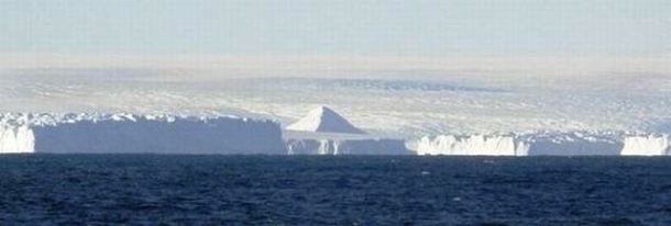
Scientist claim to possibly have found Pyramid like structures in Antarctica
http://thedailyjournalist.com/
Can it be possible that Antarctica was once warm enough in the recent past to actually have had an ancient civilization living there? And even more perplexing is the question of if an advanced culture did develop there, are there any structures still remaining that are buried underneath the ice? Amazingly a team of researchers is making the claim that they have found evidence of several ancient pyramids on the ice covered continent of Antarctica. So far, the team has not released much information on their discovery although a few pictures have been leaked on the internet recently. Besides these images, the team is remaining pretty silent with their discovery until more research can be conducted on these pyramids. The team is made up of 8 explorers from America and several European countries. Two of the pyramid structures were found approximately 10 miles inland while the third one was very close to the coastline. The team is currently planning an expedition to physically reach at least one of the pyramids to determine if it is natural or artificial. No time frame was given as to when this expedition will be taking place though
The shocking discovery of ancient man-made pyramids under the thick ice and snow of Antarctica would change our perception of human history forever. Scholars and Egyptologists have long suspected that the Sphinx is far older than first estimated, possibly over 10,000 years old. Scientists discovered that evidence of water erosion on the ancient statue, still the world’s largest, tells a story of climate change from rainy hot jungle to desert in a few thousand short years. If the climate in Egypt changed this quickly, is it not equally possible that the Antarctic climate could have also changed drastically in the same time?
Legends speak of pyramids in the Antarctica, of the lost city of Atlantis being covered not just under water, but encased in ice.
Atlantis Under Antarctica?
After WW II, scientists started to pay close attention to the issue of a supposedly once-existing civilization in Antarctica. The hypothesis is confirmed by some medieval maps and research of paleogeologists and glaciologists. In January of 1820, a Lieutenant of Russian Empire Fleet, Mikhail Lazarev discovered a new continent. In the beginning of 20th century, a Russian encyclopedia, while adducing the approximate square milage of the south pole continent, reported that it was insufficiently explored and there was no flora and fauna. The author of the article also mentioned the richness of the algae and sea life. Twenty years later, the director of the Istanbul National Museum, Khalil Edkhem, was sorting out a library of the Byzantine emperors in an old palace. He found an ancient map made on gazelle skin. On the map, there were the shores of western and southern Africa, as well as the northern shores of Antarctica. Khalil could not believe his eyes: the shores of the Queen Mod Land, to the south of the 70th parallel, was free of ice. An ancient cartographer marked a mountain chain there. The name of the cartographer was known: an admiral of the Ottoman Empire fleet, Piri Reis, who lived in the first half of 16th century. The map's authenticity was without doubt. Graphology examinations of the notes on the margin confirmed that they belonged to the admiral. In 1949, a combined British and Swedish expedition conducted intensive seismic measurements of the South Pole through the ice cap. According to the commander of 8th Technical Investigation Squadron of the US Armed Force Strategic Command, Colonel Harold Olmayer, the geographical details of the bottom part of the map (the shore of Antarctica) correspond with the results of the seismic measurements. We cannot correlate these data with the supposed level of geography in 1513.
In his notes on the map's margin, made in the early 16th century, Piri Reis explained that he was not responsible for the cartography and that the map was based on earlier sources. Some of these earlier sources, belong to his contemporaries (for example, to Christopher Columbus), while others could be dated to the 4th century B. C. if not later, because one of these sources belonged to Alexander the Great.
Of course, professional historians who specialize in ancient history could say the following: This is only one more hypothesis. What about documentation and, what would be even more desirable, trust-worthy sources? The opinion of the Turkish admiral and notes on a margin, is too open to controversy.
Therefore, I would like to present the position of the late historian and professor of Keene College in New Hampshire, USA, Charles H. Hapgood. In the late 1959, he found in the Washington Congressional Library a map created by Orontheus Phynius in 1531. Orontheus Phynius depicted Antarctica with mountains and rivers, without glaciers. The relief of the continent-s center was not marked, which, according to Hapgood, could mean that there had been an ice cap in that area. In the early 1960s, Phynius' map was studied by Doctor Richard Stratchen of the Massachusetts Technology Institute together with Hapgood. Both scientists concluded that Phynius map had indeed depicted Antarctica free of ice. The characteristics depicted were very close to the information that was obtained in 1958 by specialists from different countries.
Gerard Cremer, known in to the world as Mercator, also trusted Orontheus' evidence. He included the Phynius map into his atlas, in which several maps of Antarctica by Mercator himself were also included.
There is one other interesting feature: on Mercator's map of 1569, the west shore of South America is pictured less accurately than on the earlier map of Mercator from 1538. The reasons for this contradiction are the following: while working at the earlier map, the cartographer of 16th century proceeded from ancient sources, which were not kept for our time, and while working on the later map, he proceeded from observations of the first Spanish explorers to South America. Gerard Mercato's mistake can be excused.
In the 16th century, there were no precise methods to measure longitude: as a rule, an error could have been hundreds of kilometers! Finally, we come to Philippe Boiche, a full member of the French Academy of Science. In 1737, he published his map of Antarctica. Boiche presented a precise picture of Antarctica of the time when the continent was free of ice. On his map, the under-ice topography of the continent is presented, about which our civilization had no clear idea until 1958. Moreover, based on now-lost sources, the French academician depicted in the middle of the South Pole a body of water dividing it into two sub-continents, which were situated to the west and to the east from the line, where the Trans-Antarctic Mountains are now marked. According to the investigation in the framework of International Geophysical Year (1958), Antarctic is in fact an archipelago of large islands covered with 1.5-kilometers of ice.
Medieval maps show Antarctica without an ice cap or only partially covered with ice. The precision of the 16th century cartographers was very high and even surprising. Their data surpassed the technical possibilities even of the late Middle Ages (for example, the determination of the longitude of a relief within one minute). This level was reached by mankind only just in the late 18th century, and in some cases, the 20th. Scientists cannot comment on the high scientific level of medieval cartography. Information from almost 2000-year-old primary sources is supposed to be not well-founded. Orthodox geology claimed that the age of the Antarctica ice cap was at least 25 million years; however, recently, it has been reduced to six million years. Therefore, we should notice the following feature of the Reis map: the shore of the continent was free of ice. On the Phynius map, made 18 years after the Reis map, there is an ice cap around the South Pole within the limits of 80th and the 75th parallels. Two hundred years later, academician Boiche depicted Antarctica with glaciers. The conclusion is obvious: we can see the process of the spreading of glaciers on the southern continent. In 1949, Admiral Baird's expedition bore holes into the Ross Sea in three spots, where Orontheus Phynius marked river-beds. In the cuts, fine-grained layers were found, obviously brought to the sea from rivers, whose sources were situated in temperate latitudes (i.e. free of glaciers).
While using the nuclear dating method of doctor U. Oury from the Karnegy Institute in Washington, scientists discovered that Antarctica's rivers, which were sources of fine-dyspersated deposits, were flowing as depicted on the Phynius map, about 6,000 years ago. About 4000 years B. C., glacial sediments started to accumulate on the bottom of Ross Sea. Kernels show that before this, there was a long warm period. Therefore, the maps of Reis, Phynius, and Mercator present Antarctica when the ancient Egyptian and Shumer civilizations were newborn. This point of view is excluded by almost all professional historians and could be regarded as an operating hypothesis that cannot be verified. Any historian would say that there were no civilization of the kind in the late 5th millenium B. C. According to Doctor Jacob Hock from Illinois University, the deposits in-question could be 6 to 12 thousand years old. In September 1991, US and Egyptian archaeologists discovered at a distance of 13 km from Nile River, in Abidos, 12 large boats that belonged to Pharaohs of First Dynasty. The age of the boats is about 5,000 years. They are believed to be the most ancient vessels in the world, the leader of the expedition, D. O-Connor far, the find is estimated to be aimed for religious rites. According to Herodotus, ancient Egyptians tracked stars more than 10,000 years ago. This statement of the "father of history" is supposed to be esoteric and, therefore, not true. However, land nations seldom produced astronomers. The fact that ancient Egyptians were interested in astronomy may indicate that they inherited some knowledge from an unknown civilization of navigators. Workers of US technical intelligence determined the projection center of the Piri Reis map, whose data belongs to 4000 year B. C. The projection center was supposedly situated near today's Cairo. At that time, according to most historians, all then-existing nations were at a very low level of development. Between the 5th and 10th milleniums B. C., there was a civilization on Earth that possessed great knowledge in the field of navigation, cartography, and astronomy, which was no less advanced than that that of the 18th century. This civilization preceded our civilization, and it was not an extraterrestrial one. Its age could be several thousands years, while its location was probably on the northern shore of the most southern continent, or archipelago: Antarctica. Later, this civilization may have resettled to the north-east of Africa. The reason for the death of the civilization was the covering of Antarctica with glaciers. This process started no earlier than in the 10th millenium B. C. It cannot be excluded that there were also large-scale floods, which were regular and cause long-term local deluges (this is confirmed by archaeologists). These disasters could have destroyed most of the civilization's cultural objects. However, some fragments might be found in the future under the thickness of ice. It can also be assumed that the survivors of Antarctica kept and handed down knowledge to the ancient Egyptians. Therefore, if there will ever be an extensive exploration of Antarctica, mankind will most likely be surprised with the results.
In ‘The Myth of the Twelve World Pyramids’ author James Donahue explained the legend in March, 2006
“…The first, he said, is located under the ice in Antarctica. The others are in Tibet, Lumeria (a legendary lost continent in the Pacific region), Atlantis, Mexico, Peru, Europe, Australia, Canada,Middle East, United States and finally Egypt. I believe pyramids, or at least the remnants of what may once have been large pyramid type buildings, have been found…
What interested me was a prophetic message in the information about the Antarctic pyramid. It says this structure is a portal to other planetary systems and its function is to assist in the comings and goings of alien entities who have been part of the history of Planet Earth.
“These entities came to the planet in great spaceships and interacted with those who lived on the planet, in the water, and below the surface,” the messenger says.
The kicker comes with this: “And when this book is found, the ice shall melt from this place, revealing starships created by this pyramid, left behind as reminders of their work and interaction on your planet.”
That the book is known is a clear indication that if it is ancient, it has indeed been “found.” That we are watching with alarm the global warming reports that warn that both the Arctic and Antarctic regions are melting.
Many of us could live to see the day when the entire continent of Antarctica will be exposed, as will all of the ancient artifacts that once existed there. If a giant pyramid and starship is found there, it will change the thinking of the world forever.”
Le "Atlantidi" e Piramidi nel mio blog - The "Atlantis" and Pyramids on my blog
Italiano & English
Atlantide in Nord Europa - Atlantis in Northern Europe
Atlantide in Nord Europa - Atlantis in Northern Europe
Piramidi sotto il ghiaccio - Pyramids under the ice
L’Atlantide Svedese - Sweden’s Atlantis
Piramidi: Italia & Bosnia - Pyramids: Italy & Bosnia
Hy Brazil
...continua...

