Le Linee di Sajama - The Sajama Lines
Studio-Seminar of the University of Pennsylvania
Department of Landscape Architecture and Department of Anthropology
English & Spanish
http://nis.cml.upenn.edu/tierrasajama/
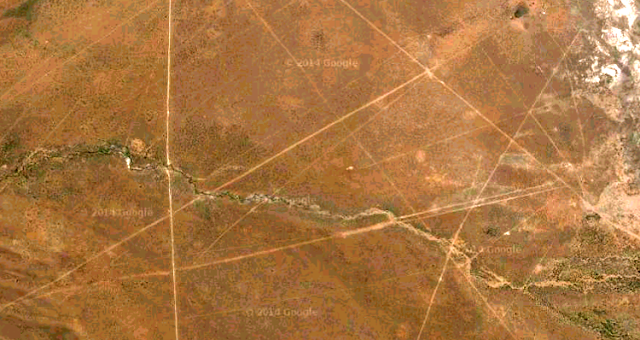
Le Linee di Sajama si trovano in Bolivia e sono formate da un reticolato di geoglifi lunghi più o meno 16.000 chilometri, coprono una superficie di circa 22.000 chilometri quadrati (cioè 15 volte più grande di quella delle più celebri Linee di Nazca) intervallati da santuari(huacas), cimiteri (chullpas) e villaggi, possibilmente progettati per definire i percorsi dei pellegrinaggi sacri, tutto databile ad almeno 3000 anni.
Il primo a parlare delle Linee di Sajama fu Aimé Felix Tschiffely nei suoi appunti di viaggio,
successivamente l’antropologo Alfred Metraux grazie al suo studio etnografico delle popolazioni Aymara della regione di Caranga le portò all’attenzione degli studiosi.
Non essendoci mai stato un vero e proprio piano di protezione dell’area la Landmarks Foundation e l’Università della Pennsylvania con il progetto “Tierra Sajama” hanno creato un database di informazioni sulla vegetazione locale, analisi, mappe, informazioni, interpretazioni, significati, riguardo le linee, ma anche sui santuari, cimiteri, villaggi per individuare i possibili corrispondenze simboliche con le linee
The Sajama Lines in Bolivia are a network of geoglyphs long 16.000 km, covering an area of about 22.000 square kilometers (15 about 10 times the size of the most famous Nazca Lines) interspersed with shrines ( huacas), cemeteries (chullpas) and villages, possibly designed to define the paths of sacred pilgrimages, all dating back at least 3.000 years.
The first to speak of lines of Sajama was Aimé Felix Tschiffely in his travel notes,
subsequently the anthropologist Alfred Metraux thanks to his ethnographic study of the populations of the Aymara region Caranga brought her to the attention of scholars.
Since there has never been a real plan to protect the area the Landmarks Foundation and the University of Pennsylvania with the "Tierra Sajama" have created a database of information on the local vegetation, analysis, maps, information, interpretations, meanings, about the lines, but also shrines, cemeteries, villages to identify possible matches with symbolic lines
...continua...


